Search Term Record
Metadata
Name |
Porter's Rock |
Related Records
-
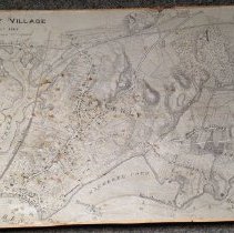
008.049.001 - Map
A map of Beverly Village drawn about 1848 from the office of the City Engineer. Topographic information, water depth and the location of structures and wharves are provided. The Eastern Railroad and bridge are also present. Beverly Creek, Porter's Rock, Tuck's Point, Mackerel Cove, Hospital Point Light, Woodberry's Point, Mingo's Brach and Curtis Point are all identified.
Record Type: Archive